Portfolio
Projects
Remote Sensing of Defensible Space Compliance to Enhance Wildfire Preparedness
Other Contributors
Description
- This project was an investigation into the possibility of building a machine learning model to predict compliance with defensible space rules in Santa Barbara County
- The models were based off of 5 years of Santa Barbara County Fire Department parcel inspections data, as well as variables like NDVI, rainfall, land use, past compliance status, and random convolutional features.
Climate Modeling Analysis of Indian Monsoons using CMIP6
Other Contributors
Description
- We leverage CMIP6 climate models to analyze and visualize historical and predicted monsoon season conditions, specifically as they relate to precipitation and windspeed.
How Spider Traits Differ Across the World
Description
- Ingested data from NMBE World Spider Catalog, World Spider Trait Database, WWF Terrestrial Ecoregions of the World, and geoBoundaries into a SQL database to determine patterns in spider traits and global biomes among 15000+ species.
Houston 2021 Blackout Analysis
Description
- A geospatial analysis of the 2021 TX power crisis from an EJ perspective.
California Fisheries Habitat Suitability Mapping Function
Description
- Code and workflow for a function that produces a habitat suitability map for any CA coast dwelling species based on user inputted abiotic parameter values.
The Biodiverisity Intactness Index and Biodiveristy Decline in Phoenix, AZ
Description
- A geospatial analysis of the change in the Biodiversity Intactness Index within the Phoenix, AZ area from 2017 to 2020.
Fire Scars from the 2017 Thomas Fire in Santa Barbara and Ventura
Description
- An analysis of impacts from the 2017 Thomas Fire in Santa Barbara County, CA.
Visualizations
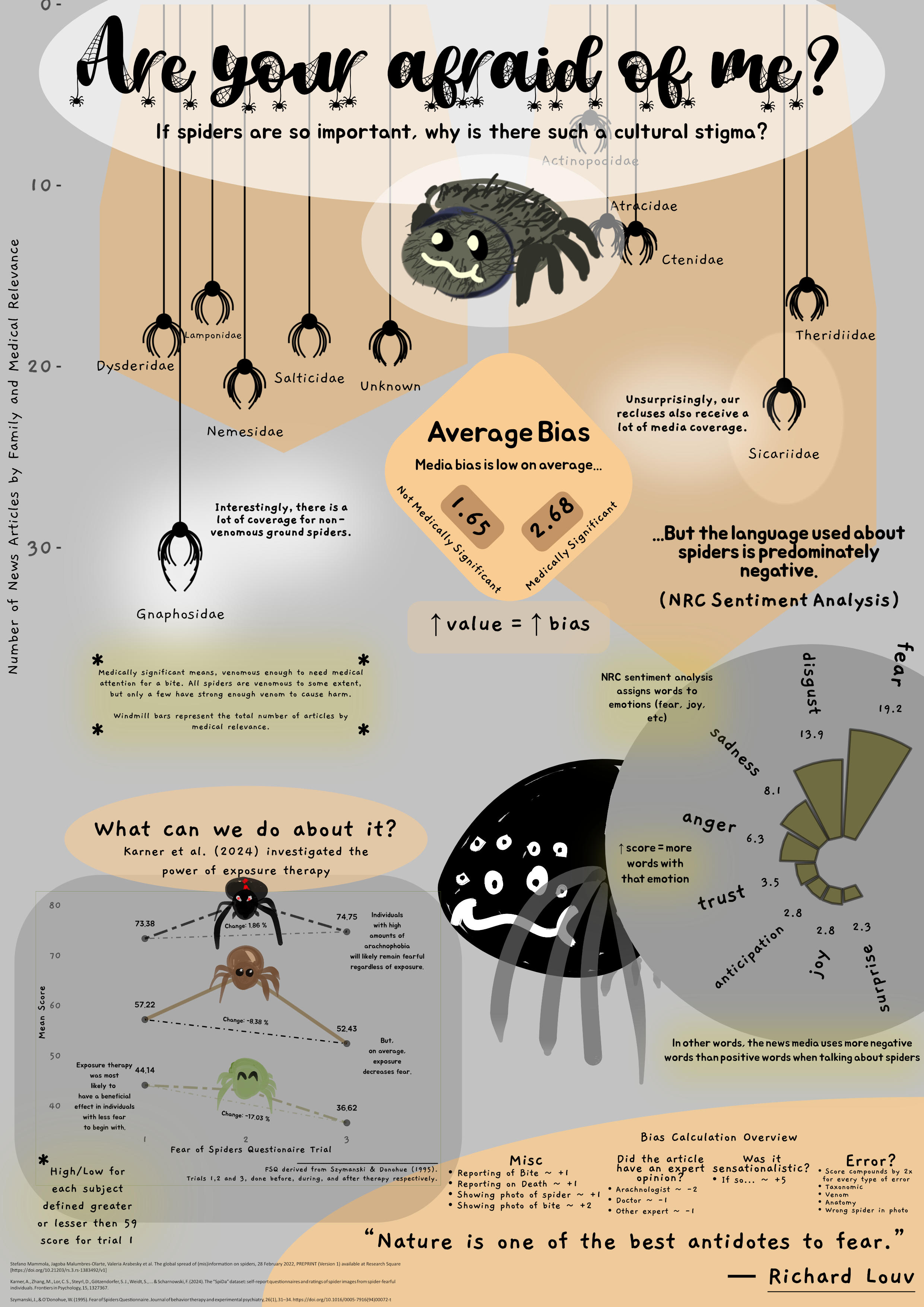
Are You Afraid of Me?
- Infographic investigating societal attitutes towards and bias against spiders.